Since the past month or so newspapers, TV channels and Social media is buzzing about the tension building up at the India-China border. Have you wondered why these tensions are on the higher side and why are there speculations about India-China War? Do these speculations come true? What is India's argument? What is China Claiming? let us understand in detail the back story and in the end, we bring you our own Vishleshan.

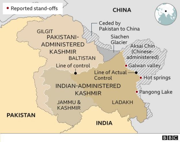
India shares its second-largest land border of approximately 4056km only behind Bangladesh 4156km. It shares borders with China in three areas and they are divided into the eastern sector in the Arunachal Pradesh this line is known as McMahon Line, the central sector in the states of Himachal Pradesh, Sikkim, and Uttarakhand and in the western side in the Union Territory Ladakh. The borderlines in the central and western sectors are called Line of Actual Control (LAC). Unfortunately, the majority of these lines are unorganized and both the countries failed miserably in reorganizing these lines thanks to the great colonial rule.

pic: The Economist
According to sources, in the past one month, the western region has been heating up with troops build up on the Chinese side in Galwan Valley, Hot springs, and Pangong Lake. This advancement is mainly due to the decision of Indian Govt. to carry out the construction of a road connecting Leh and Darbuk Beg Oldi(DBO). The DBO is home to the world’s highest airstrip at 16000ft above sea level. This move by China is pathetic as previously when China had carried out certain advancements on its side of the border, India did not obstruct. However, even India is retaliating by engaging more troops on its side of the border. The negotiations attempted between the border officials on either side failed to draw a stalemate in the recent face-off. Now, its time for the higher rank officials to negotiate a ceasefire.

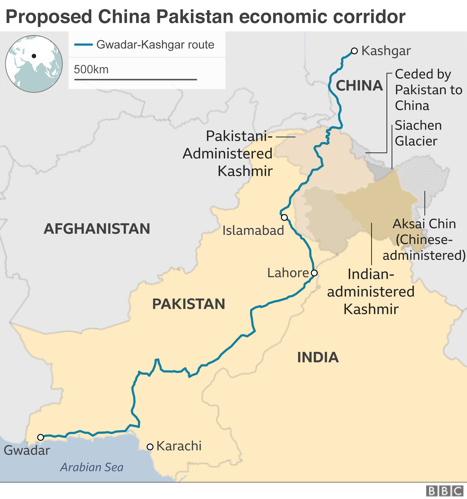
Interestingly, on the western side the Chinese Govt. is planning to build an economic corridor between China and Pakistan through the POK to which India strongly objects citing that the POK (Baluchistan) region rightfully belongs to India and Pakistan has occupied it illegally.
 pic:
pic: Now what is the way out?
Both the countries know that they would be weakened financially and in terms of men if tensions escalate and war erupts. So, there are some de-escalating agreements signed between both the nations multiple times over the years like 1993,1996,2005,2012, and 2013, where the nations tried to chalk out their course of action during uncertain times. Hence, the possibility of war is unlikely.
Thankfully, both countries-maintained rhetoric public calm which certainly helps them to make better decisions. There should be both Diplomatic pressure and Political pressure enforced by the Indian Govt. to maintain the sovereignty of the country.
Abhishek Reddy
Please Subscribe to get our latest articles delivered to your mail.
Information is super..
ReplyDelete
ReplyDeleteGot to know that how the present relationship with china is being.
Applaudable attempt.
Better than classic News paper reading,
ReplyDeleteBurrapaadu gaa raasav
Explination is good ..keep go on..
ReplyDeleteOne has to know what is happening in the premises of their country. Thank you for letting us know. Much needed topic this is.
ReplyDeleteGood detailed explanation
ReplyDeleteGlad to get some information regarding our borders. Good presentation, easy to understand not like Shashi Tharoor's speech. Keep up the good work.
ReplyDeleteGud bro its more informative
ReplyDeleteGood thing explained clearly and it's informative and got some more information about our country borders
ReplyDelete1)I think so the conclusion should be somewhat better
ReplyDelete2) IN the starting why did you thank colonial rule?
3) you may give some information about the advantages of rod that India is planning to construct between leg and DBO